
Market Report · July 15, 2026

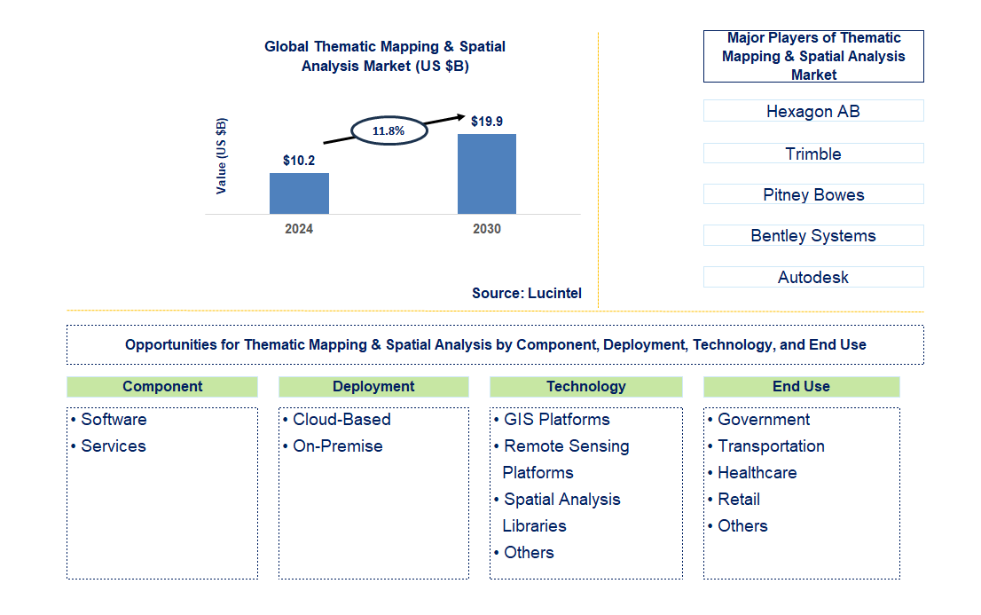
Key data points: The market size in 2030 = $19.9 billion, growth forecast = 11.8% annually for the next 6 years. Scroll below to get more insights. This market report covers trends, opportunities, and forecasts in the global thematic mapping & spatial analysis market to 2030 by component (software and services), deployment (cloud-based and on-premise), technology (GIS platforms, remote sensing platforms, spatial analysis libraries, and others), end use (government, transportation, healthcare, retail, and others), and region (North America, Europe, Asia Pacific, and the Rest of the World)
We'll send your sample report shortly.
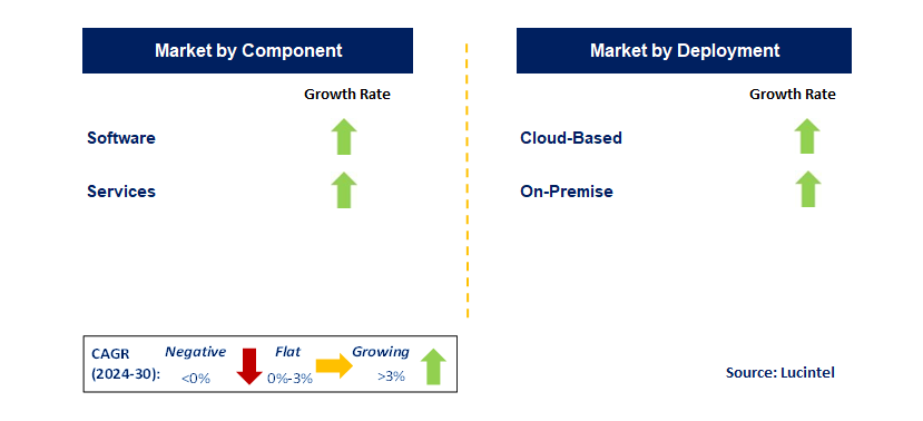
• Lucintel forecasts that, within the component category, software is expected to witness a higher growth over the forecast period.
• Within the end category, government is expected to witness the highest growth.
• In terms of region, APAC is expected to witness the highest growth over the forecast period. Gain valuable insights for your business decisions with our comprehensive 150+ page report.
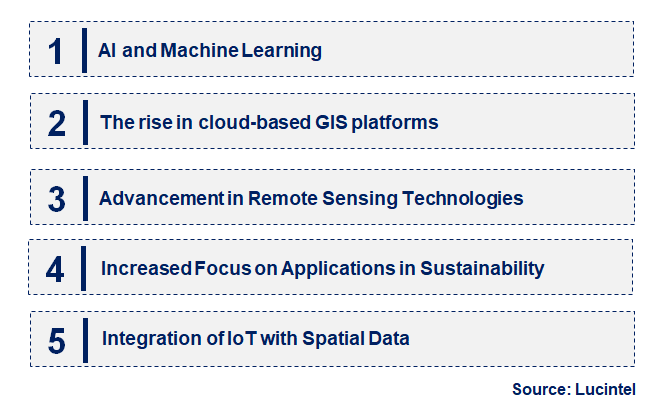
• AI and Machine Learning: The integration of AI and machine learning significantly influences thematic mapping and spatial analysis. These technologies have improved data processing, pattern recognition, and predictive modeling. As a result, spatial analysis has advanced with improved detail and accuracy, making it better for decision-making and more efficient for various applications such as environmental monitoring and city planning.
• The Rise of Cloud-Based GIS Platforms: Cloud-based GIS platforms offer scalability, flexibility, and a collaborative nature. They are convenient for users who can analyze spatial data from any location, leading to real-time sharing and collaboration on information. The growth of these systems into full-fledged dynamic and responsive spatial analysis has been significant in fields related to urban planning, disaster management, and business intelligence.
• Advancement in Remote Sensing Technologies: Improvements in sensing technologies, including higher-resolution satellites and drones, have enhanced data collection capabilities. The spatial data produced is highly thematic and up-to-date, providing high accuracy in thematic mapping and spatial analysis. This trend supports applications in environmental monitoring, agriculture, and infrastructure development.
• Increased Focus on Applications in Sustainability: There is a growing application of thematic mapping and spatial analysis in addressing environmental and sustainability concerns. Tools are being designed to measure environmental impacts, monitor trends in climate change, and manage natural resources. This trend supports global sustainability goals and helps related projects to be implemented more successfully in areas such as conservation, renewable energy, and urban resilience.
• Integration of IoT with Spatial Data: The integration of Internet of Things (IoT) technologies with spatial data opens new avenues for real-time monitoring and analysis. This continuous stream of data from IoT sensors can be integrated with spatial analysis to enhance decision-making in smart cities, infrastructure management, and environmental monitoring. The emerging trends in the thematic mapping and spatial analysis market include AI integration, cloud-based GIS, advancements in remote sensing, increased emphasis on environmental issues, and IoT integration. These trends drive innovation, enhance data accuracy, and broaden possible applications, thereby contributing to growth and development across various sectors.
• Enhanced Data Integration Capabilities: New features in the system include enhanced data integration capabilities that can integrate spatial data from different sources. Improved integration of spatial data enhances comprehensive analysis and provides more accurate input. This integration supports applications in urban planning, environmental monitoring, and business intelligence.
• Deployment of Advanced GIS Tools: There is a deployment of advanced GIS tools that enable more complex spatial analysis. For instance, the tools provide more functionality, such as 3D modeling, real-time data visualization, and advanced analytics. Their adoption ensures better decision-making and effective management of spatial data across sectors.
• Increased Use of High-Resolution Satellite Imagery: High-resolution satellite imagery is associated with improved detail and precision in thematic mapping. These changes enhance spatial analysis to the highest accuracy for applications that include land use planning, environmental monitoring, and disaster management. High-resolution imagery provides valuable insights for effective decision-making.
• Expansion of Spatial Data Platforms: The expansion of spatial data platforms makes them more accessible and usable. They are user-friendly, collaborative, and easily integrate with other data sources. This expansion supports broader adoption of thematic mapping and spatial analysis tools by various industries to improve their decision-making processes through data-driven analysis.
• Developments in Remote Sensing Technology: Recent advancements include the introduction of drones and very advanced satellite sensors, which expand acquisition capabilities. These technologies offer high-quality spatial data for more accurate analyses and monitoring, thus supporting applications in agriculture, environmental management, and urban planning. The thematic mapping and spatial analysis market is impacted by improved data integration, advancements in GIS tools, high-resolution satellite imagery, increasing spatial data platforms, and developing remote sensing technology. These key developments are essential for innovation, improving accuracy, and supporting various uses and applications, contributing to the growth and evolution of the market.
• Urban Planning and Smart Cities: The significant trend related to city development, in terms of urban planning and smart city development, is yielding considerable growth opportunities. Thematic mapping and spatial analysis are essential tools for optimizing infrastructure, resource management, and further improving the urban environment. This opportunity supports the needs of sustainable and more efficient cities.
• Environmental Monitoring and Management: Environmental monitoring and management present large-scale growth opportunities. Spatial analysis tools have emerged as effective means of monitoring changes in the environment, assessing impacts, and managing resources. This opportunity aligns with global sustainability goals of conservation, adaptation to climate change, and resource management.
• Agricultural Management: Increasingly, agricultural management involves thematic mapping and spatial analysis. The applications of these tools in precision farming, crop monitoring, and resource optimization open opportunities to enhance agriculture in terms of improved productivity and sustainable practices.
• Disaster Management and Emergency Response: Disaster management and emergency response is a domain that holds immense potential for improvement. Spatial analysis tools provide critical information for risk assessment, response planning, and recovery activities. Improving operational efficiency in disaster management strategies and supporting resilience-building initiatives are key aspects of this potential.
• Business Intelligence and Market Analysis: The use of thematic mapping and spatial analysis in business intelligence and market analysis offers great opportunities for growth. Spatial data provides insights into trends in the market, consumer behavior, and the competitive landscape. This supports data-driven decision-making and strategic planning. Strategic growth opportunities in the thematic mapping and spatial analysis market can be identified in urban planning, environmental monitoring, agriculture, disaster management, and business intelligence. Innovation, capability building, and sectoral expansion can all be supported through these opportunities.
• Technological Advancements: Advances in technology are significant drivers for the market. Improved GIS tools and remote sensing technologies have enhanced the capabilities required for acquiring, processing, and analyzing data for thematic mapping and spatial analysis. This has driven demand for advanced spatial solutions, supporting growth in the market.
• Increasing Need for Data-Driven Decision Making: Demand is increasing in urban planning, environmental management, and business intelligence across different sectors. This will fuel market growth and adoption because thematic mapping and spatial analysis offer valuable insights to support informed decisions.
• Expansion of Smart Cities and Urban Development: The development of smart cities and urban initiatives opens enormous growth possibilities. Spatial analysis tools are essential for optimizing infrastructure, resource management, and improving the quality of the urban environment. This driver promotes the adoption of thematic mapping solutions in projects related to urban planning and smart cities.
• Environmental Sustainability Focus: The need to pursue environmental sustainability, coupled with climate change adaptation, boosts the demand for spatial analysis tools. Environmental tools aid in monitoring environmental phenomena, resource management, and conservation. This driver aligns with the broader aim of sustainability, supporting growth in environmental applications.
• Growth of Remote Sensing Technologies: The growth of remote sensing technologies, such as satellites and drones for collecting spatial data, is another significant driver. Enhancements in real-time data and high-resolution imagery promote more precise spatial analyses and monitoring. This driver supports the expansion of thematic mapping applications across various sectors. Challenges in the thematic mapping and spatial analysis market include:
• High Costs of Advanced Technologies: Advanced GIS tools and remote sensing technologies can be very costly, presenting challenges for large-scale adoption. The equipment and software may be expensive, limiting accessibility for some organizations and thereby hindering market growth. Managing costs and offering cost-effective solutions is a key challenge.
• Data Privacy and Security Concerns: The market may face challenges related to data privacy and security in spatial data management. Compliance with regulations and protecting sensitive information are crucial for building trust and fostering market growth. Addressing privacy and security issues is fundamental for market stability.
• Complexity of Data Integration: Integrating spatial data from different sources poses complex challenges. Advanced solutions are necessary to ensure seamless integration and guarantee data interoperability. This complexity must be overcome for thematic mapping and spatial analysis to be carried out effectively. The thematic mapping and spatial analysis market is growing rapidly due to technological advancements, data-driven decision making, expansion in smart cities, environmental sustainability, and the growth of remote sensing technologies. However, high technology costs, data privacy issues, and integration complexities remain significant challenges. Addressing these issues is critical for achieving market stability and growth. Understanding these factors is pivotal while navigating the market and identifying opportunities.
• Hexagon AB
• Trimble
• Pitney Bowes
• Bentley Systems
• Autodesk
• SuperMap
• Tom Tom
• Software
• Services
• Cloud-Based
• On-Premise
• GIS Platforms
• Remote Sensing Platforms
• Spatial Analysis Libraries
• Others
• Government
• Transportation
• Healthcare
• Retail
• Others
• North America
• Europe
• Asia Pacific
• The Rest of the World
• United States: The latest trends in thematic mapping and spatial analysis in the United States focus on enhancing machine learning and AI. Data analysis is improved and better visualized through the use of algorithms for predictive modeling and pattern recognition. Another reason for increased progress in urban planning, disaster response, and resource management in many countries is the availability of cloud-based GIS platforms that provide the ability to scale and collaborate in managing spatial data.
• China: China has made significant investments in thematic mapping and spatial analysis through the development of satellite imagery and advanced GIS. The country is investing heavily in space-based data collection for urban development and environmental monitoring. It also employs big data analytics to enhance the interpretation of spatial data and improve decision-making procedures. These advancements greatly expand capabilities in infrastructure planning, environmental protection, and disaster management.
• Germany: Thematic mapping and spatial analysis in Germany are characterized by high accuracy and sustainability. The country is utilizing the most advanced GIS tools for detailed environmental assessments and urban planning activities. The integration of spatial analysis with renewable energy planning and adaptation to climate change is evident in Germany's initiatives. Innovations in data acquisition and modeling serve as catalysts that aid environmental goals and smart city initiatives by enhancing land use planning and resource management.
• India: In India, emerging themes focus on improving physical infrastructure and managing resources through advancements in geographic information systems technology. Spatial analytical tools are being applied in agriculture management, urban planning, and disaster risk management. The deployment of satellite-based technologies and open-source GIS platforms is gaining acceptance to broaden access to data and support the decision-making process. Initiatives are designed to address the needs of India's population concerning resource distribution and climate change.
• Japan: Recent trends in thematic mapping and spatial analysis in Japan involve advancing disaster management and enhancing urban resilience. Japan is employing advanced GIS and remote sensing technologies to improve preparation and response during earthquakes and tsunamis. The country has also been investing in smart city projects that integrate spatial data with IoT technologies to enhance city management. These efforts have contributed to greater disaster resilience, optimization of existing urban infrastructure, and improved environmental monitoring.
• Hexagon AB
• Trimble
• Pitney Bowes
• Bentley Systems
• Autodesk
• SuperMap
• Tom Tom Q6. Which thematic mapping & spatial analysis market segment will be the largest in future? Answer: Lucintel forecasts that software is expected to witness higher growth over the forecast period. Q7. In thematic mapping & spatial analysis market, which region is expected to be the largest in next 6 years? Answer: APAC is expected to witness the highest growth over the forecast period. Q.8 Do we receive customization in this report? Answer: Yes, Lucintel provides 10% customization without any additional cost.


Choose a license that fits your team. Instant PDF delivery.
Prices exclude taxes. Instant delivery. Custom licensing available on request.
Market Report · July 15, 2026
Market Report · June 26, 2026
Market Report · June 24, 2026
Trusted partner for strategic intelligence and business growth


Receive a complimentary market analysis tailored to your industry. Our analysts will identify key growth opportunities and competitive dynamics specific to your business.

Market size, growth rate, and key trend analysis for your specific sector.

Top competitor positioning and market share analysis.

Strategic recommendations backed by data-driven insights.
Get curated market intelligence and competitive moves straight to your inbox.
By subscribing, you agree to receive our monthly insights. Unsubscribe anytime.
Receive a complimentary market analysis tailored to your industry. Our analysts will identify key growth opportunities and competitive dynamics specific to your business.
Market size, growth rate, and key trend analysis for your specific sector.
Top competitor positioning and market share analysis.
Strategic recommendations backed by data-driven insights.
Get curated market intelligence, emerging trends, and competitive moves straight to your inbox each month.
By subscribing, you agree to receive our monthly insights. Unsubscribe anytime.
We'll send your sample report shortly.