Market Report · September 19, 2025

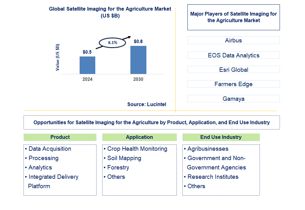
Key data points: The market size in 2030 = $0.8 billion, growth forecast = 8.1% annually next 6 years. Scroll below to get more insights. This market report covers trends, opportunity and forecast in Satellite Imaging for the Global Agriculture Market to 2030 by product (data acquisition, processing, analytics, and integrated delivery platform), application (crop health monitoring, soil mapping, forestry, and others), end use industry (agribusinesses, government and non-government agencies, research institutes, and others), and region (North America, Europe, Asia Pacific, and the Rest of the World)
We'll send your sample report shortly.
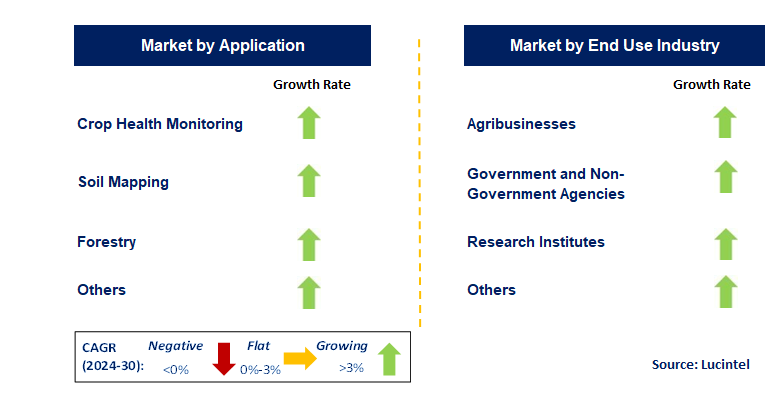
• Lucintel forecasts that crop health monitoring will remain the largest segment over the forecast period because it helps in enabling precise digital agriculture practices and large-scale pest detection, as well as farmers and agronomists can easily monitor and optimize crop health and assess variations in yield on a seasonal basis.
• Through this market, agribusiness will remain the largest segment over the forecast period due to improvement in satellite image and remote sensing technology day by day, which assists the farm managers and modern farmers to keep track of conditions and monitoring growth, weather, and carbon.
• North America will remain the largest region over the forecast period due to growing utilization of satellite imaging for precise crop health monitoring and pest detection. A more than 150-page report is developed to help in your business decisions.
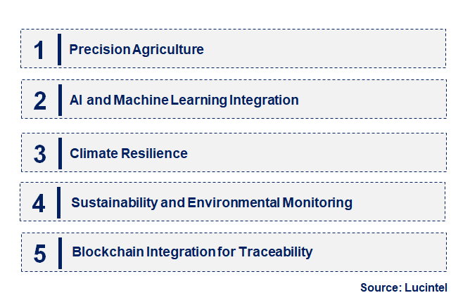
• Precision Agriculture: The integration of satellite imaging with precision agriculture tools is enabling farmers to manage crops with greater accuracy. This trend supports the efficient use of inputs such as water, fertilizers, and pesticides, reducing costs and environmental impact while improving yields.
• AI and Machine Learning Integration: The application of AI and machine learning to satellite imagery is enhancing the accuracy of agricultural forecasting. These technologies analyze vast amounts of satellite data to predict crop yields, monitor plant health, and identify potential issues before they become critical.
• Climate Resilience: Satellite imaging is playing a crucial role in helping farmers adapt to climate change. By providing detailed data on weather patterns, soil moisture, and crop conditions, satellite technology enables more resilient farming practices that mitigate the effects of extreme weather events.
• Sustainability and Environmental Monitoring: The use of satellite imaging for monitoring environmental factors, such as deforestation, soil erosion, and water usage, is growing. This trend aligns with global efforts to promote sustainable agriculture and reduce the environmental footprint of farming activities.
• Blockchain Integration for Traceability: Satellite imaging is increasingly being integrated with blockchain technology to enhance traceability in the agricultural supply chain. This trend allows for the verification of crop origins, ensuring transparency and accountability from farm to table. These emerging trends are transforming satellite imaging into a powerful tool for modern agriculture, driving innovation in crop management, sustainability, and supply chain transparency. As these technologies continue to evolve, they are poised to play an even more significant role in shaping the future of global agriculture market.
• High-Resolution Imaging: Advancements in satellite technology have led to the availability of high-resolution imagery, allowing for more detailed monitoring of crop health and soil conditions. This development is improving the precision of agricultural practices and enabling targeted interventions.
• Real-Time Data Access: The increasing availability of real-time satellite data is transforming agricultural management. Farmers can now access up-to-date information on weather conditions, crop growth, and soil health, enabling timely decision-making and reducing the risk of crop failure.
• Integration with IoT: The integration of satellite imaging with IoT devices is enhancing the ability to monitor and manage agricultural activities remotely. This development is particularly beneficial for large-scale farming operations, where real-time data is critical for efficient resource allocation.
• Expansion of Satellite Constellations: The deployment of new satellite constellations specifically designed for agricultural monitoring is expanding the coverage and frequency of data collection. This development is providing farmers with more consistent and reliable data, supporting better crop management practices.
• Public-Private Partnerships: Collaboration between governments, research institutions, and private companies is driving innovation in satellite imaging for agriculture. These partnerships are facilitating the development of new technologies and applications that are tailored to the specific needs of the agricultural sector. These recent developments are significantly enhancing the capabilities of satellite imaging in agriculture, leading to more efficient, sustainable, and resilient farming practices. As these technologies continue to advance, they will play a crucial role in addressing global food security challenges.
• Precision Farming: Satellite imaging enables precision farming by providing detailed data on crop health, soil conditions, and weather patterns. This growth opportunity is driving the adoption of data-driven farming practices that optimize inputs, increase yields, and reduce environmental impact.
• Yield Prediction and Forecasting: The use of satellite imaging for yield prediction and forecasting is gaining traction. This application provides farmers and agribusinesses with accurate insights into expected crop outputs, allowing for better planning and resource allocation.
• Water Resource Management: Satellite imaging is crucial for effective water resource management in agriculture. By monitoring soil moisture levels and water usage, this technology helps farmers optimize irrigation practices, conserve water, and ensure the sustainability of their operations.
• Supply Chain Traceability: The integration of satellite imaging with blockchain technology is enhancing supply chain traceability in agriculture. This growth opportunity supports transparency and accountability, ensuring that agricultural products meet quality standards and are sustainably sourced.
• Sustainable Land Management: Satellite imaging is playing a key role in promoting sustainable land management practices. By providing data on land use, deforestation, and soil erosion, this technology supports efforts to protect natural resources and maintain agricultural productivity. The strategic growth opportunities enabled by satellite imaging are transforming the agricultural sector. As these applications continue to evolve, they are poised to drive significant advancements in crop management, sustainability, and supply chain transparency, ultimately contributing to global food security.
• Airbus
• EOS Data Analytics
• Esri Global
• Farmers Edge
• Gamaya
• Iceye Oy
• Planet Labs PBC
• European Space Imaging
• Satellogic
• SpaceKnow
• Data Acquisition
• Processing
• Analytics
• Integrated Delivery Platform
• Crop Health Monitoring
• Soil Mapping
• Forestry
• Others
• Agribusinesses
• Government and Non-Government Agencies
• Research Institutes
• Others
• North America
• Europe
• Asia Pacific
• The Rest of the World
• United States: The U.S. has seen increased adoption of high-resolution satellite imagery for precision agriculture. The USDA has expanded its use of satellite data for crop forecasting and environmental monitoring, enhancing farmers' ability to make informed decisions about planting and resource management.
• China: China has made strides in using satellite imaging to address food security challenges. The Chinese government has invested in satellite-based monitoring systems to track crop conditions and soil health, helping to optimize agricultural practices and boost productivity in rural areas.
• Germany: Germany has focused on integrating satellite imaging with AI and machine learning to improve agricultural forecasting and resource management. The country’s commitment to sustainable agriculture is evident in its use of satellite data to monitor environmental impacts and ensure compliance with EU regulations.
• India: India has leveraged satellite imaging to tackle agricultural challenges such as drought and soil degradation. The Indian Space Research Organisation (ISRO) has developed advanced satellite systems that provide real-time data to farmers, aiding in efficient water management and crop planning.
• Japan: Japan has focused on using satellite imaging to enhance smart farming practices. The Japanese government and private sector have collaborated to develop satellite-based platforms that provide detailed agricultural insights, enabling farmers to optimize crop yields and reduce environmental impact.
• Airbus
• EOS Data Analytics
• Esri Global
• Farmers Edge
• Gamaya
• Iceye Oy
• Planet Labs PBC
• European Space Imaging
• Satellogic
• SpaceKnow Q6. Which satellite imaging for the agriculture market segment will be the largest in future? Answer: Lucintel forecasts that crop health monitoring will remain the largest segment over the forecast period because it helps in enabling precise digital agriculture practices and large-scale pest detection, as well as farmers and agronomists can easily monitor and optimize crop health and assess variations in yield on a seasonal basis. Q7. In satellite imaging for the agriculture market, which region is expected to be the largest in next 5 years? Answer: North America will remain the largest region over the forecast period due to growing utilization of satellite imaging for precise crop health monitoring and pest detection. Q.8 Do we receive customization in this report? Answer: Yes, Lucintel provides 10% customization without any additional cost.


Choose a license that fits your team. Instant PDF delivery.
Prices exclude taxes. Instant delivery. Custom licensing available on request.
Market Report · September 19, 2025
Market Report · July 13, 2026
Market Report · July 10, 2026
Trusted partner for strategic intelligence and business growth


Receive a complimentary market analysis tailored to your industry. Our analysts will identify key growth opportunities and competitive dynamics specific to your business.

Market size, growth rate, and key trend analysis for your specific sector.

Top competitor positioning and market share analysis.

Strategic recommendations backed by data-driven insights.
Get curated market intelligence and competitive moves straight to your inbox.
By subscribing, you agree to receive our monthly insights. Unsubscribe anytime.
Receive a complimentary market analysis tailored to your industry. Our analysts will identify key growth opportunities and competitive dynamics specific to your business.
Market size, growth rate, and key trend analysis for your specific sector.
Top competitor positioning and market share analysis.
Strategic recommendations backed by data-driven insights.
Get curated market intelligence, emerging trends, and competitive moves straight to your inbox each month.
By subscribing, you agree to receive our monthly insights. Unsubscribe anytime.
We'll send your sample report shortly.