Market Report · July 31, 2026

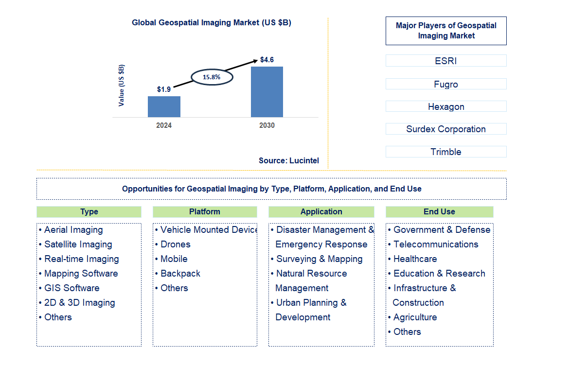
Key data points: The market size in 2030 = $4.6 billion, growth forecast = 15.8% annually next 6 years. Scroll below to get more insights. This market report covers trends, opportunities, and forecast in the global geospatial imaging market to 2030 by type (aerial imaging, satellite imaging, real-time imaging, mapping software, GIS software, 2D & 3D imaging, and others), platform (vehicle mounted device, drones, mobile, backpack, and others), application (disaster management & emergency response, surveying & mapping, natural resource management, urban planning & development, and others), end use (government & defense, telecommunications, healthcare, education & research, infrastructure & construction, agriculture, and others), and region (North America, Europe, Asia Pacific, and the Rest of the World)
We'll send your sample report shortly.
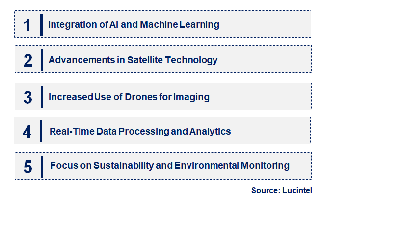
• Integration of AI and Machine Learning: AI and machine learning are transforming geospatial imaging by enhancing data analysis capabilities. The integration of AI and machine learning technologies enables more accurate and efficient analysis of large volumes of geospatial data. These technologies improve pattern recognition, predictive analytics, and automated image processing. AI-driven algorithms enhance the accuracy of feature extraction, land-use classification, and change detection, providing deeper insights and facilitating more informed decision-making in various applications, including urban planning and environmental monitoring.
• Advancements in Satellite Technology: Innovations in satellite technology are expanding the capabilities of geospatial imaging. Recent advancements include the development of high-resolution imaging satellites, larger satellite constellations, and improved data acquisition techniques. These innovations enhance the spatial and temporal resolution of satellite imagery, providing more detailed and frequent observations of Earth's surface. Enhanced satellite technology supports a wide range of applications, from precision agriculture and urban management to disaster response and environmental monitoring.
• Increased Use of Drones for Imaging: Drones are increasingly being used for high-resolution geospatial imaging. The use of drones in geospatial imaging offers several advantages, including the ability to capture high-resolution imagery at lower costs and with greater flexibility compared to traditional methods. Drones are used for detailed mapping, infrastructure inspection, and environmental monitoring. Advances in drone technology, including improved sensors and longer flight times, are driving their adoption in both commercial and research applications, enhancing the precision and accessibility of geospatial data.
• Real-Time Data Processing and Analytics: Real-time data processing is becoming a critical component of geospatial imaging. The ability to process and analyze geospatial data in real time is increasingly important for applications requiring timely information, such as disaster management and traffic monitoring. Advances in computing technology and data streaming enable rapid processing of large datasets, allowing for real-time insights and decision-making. This trend supports dynamic applications and improves the responsiveness and effectiveness of geospatial data utilization.
• Focus on Sustainability and Environmental Monitoring: There is a growing emphasis on using geospatial imaging for sustainability and environmental monitoring. Geospatial imaging technologies are being leveraged to monitor and manage environmental resources, track climate change impacts, and support conservation efforts. High-resolution imagery and data analysis tools provide valuable insights into land use, deforestation, pollution, and natural resource management. This trend reflects a broader commitment to sustainability and environmental stewardship, with geospatial imaging playing a key role in addressing global environmental challenges. The geospatial imaging market is evolving with emerging trends such as the integration of AI and machine learning, advancements in satellite technology, increased use of drones, real-time data processing, and a focus on sustainability. These trends are enhancing the capabilities of geospatial imaging, expanding its applications, and addressing key challenges in various sectors. Staying abreast of these trends is essential for stakeholders to harness new opportunities, drive innovation, and effectively leverage geospatial data for diverse and impactful applications.
• Advancements in Satellite Technology: Recent advancements in satellite technology are significantly enhancing geospatial imaging capabilities. Innovations such as higher resolution sensors, expanded satellite constellations, and more frequent data collection are improving the quality and availability of geospatial data. These advancements provide more detailed and accurate imagery, supporting applications in precision agriculture, urban planning, and environmental monitoring. Enhanced satellite technology also enables better tracking of climate change and natural disasters, contributing to more effective management and response strategies.
• Integration of AI and Machine Learning: The integration of artificial intelligence (AI) and machine learning (ML) is revolutionizing geospatial data analysis. AI and ML technologies are enabling more sophisticated data processing and analysis, including automated feature extraction, pattern recognition, and predictive analytics. These advancements enhance the accuracy and efficiency of geospatial imaging, allowing for better decision-making and insight generation. Applications such as land-use classification, infrastructure monitoring, and disaster response are benefiting from improved data interpretation and actionable intelligence.
• Growth of Drone Technology: The use of drones in geospatial imaging is expanding due to their high-resolution capabilities and flexibility. Drones are increasingly used for capturing detailed, high-resolution imagery and performing tasks such as infrastructure inspections, agricultural monitoring, and environmental assessments. Recent advancements in drone technology, including improved sensors and longer flight durations, are making them more versatile and cost-effective. This growth supports more granular and localized data collection, enhancing the precision and applicability of geospatial imaging solutions.
• Real-Time Data Processing and Streaming: Real-time data processing and streaming are becoming essential in the geospatial imaging market. The ability to process and analyze geospatial data in real-time is crucial for applications requiring immediate information, such as disaster response, traffic management, and security monitoring. Advances in computing technology and data infrastructure are enabling faster data processing and delivery, improving the timeliness and relevance of geospatial insights. This capability supports more dynamic and responsive applications, enhancing the overall effectiveness of geospatial imaging.
• Emphasis on Sustainability and Environmental Monitoring: There is an increased focus on using geospatial imaging for sustainability and environmental monitoring. Geospatial imaging technologies are being leveraged to track and manage environmental resources, monitor climate change, and support conservation efforts. High-resolution imagery and advanced data analytics provide valuable insights into land use, deforestation, and pollution levels. This emphasis on sustainability aligns with global environmental goals and enhances the role of geospatial imaging in promoting responsible resource management and ecological preservation. Recent developments in the geospatial imaging market, including advancements in satellite technology, the integration of AI and machine learning, the growth of drone technology, real-time data processing, and a focus on sustainability, are reshaping the industry. These innovations are enhancing the capabilities and applications of geospatial imaging, leading to more accurate, timely, and actionable data. As these trends continue to evolve, they will drive further growth and transformation in the market, offering new opportunities and addressing emerging challenges in various sectors.
• Urban Planning and Smart Cities: Geospatial imaging provides valuable insights for urban planning and smart city development. As cities grow and evolve, geospatial imaging technologies can support planning and development by providing detailed spatial data and analysis. Applications include monitoring infrastructure, optimizing land use, and managing urban expansion. The integration of geospatial data into smart city initiatives enhances urban management and decision-making, promoting more efficient and sustainable city development.
• Precision Agriculture: Geospatial imaging is increasingly used in precision agriculture to improve crop management. By utilizing high-resolution imagery and data analytics, farmers can optimize crop production, monitor soil health, and manage resources more effectively. Geospatial imaging enables targeted interventions, such as precise irrigation and nutrient application, leading to increased yields and reduced environmental impact. This opportunity supports the growth of precision agriculture technologies and enhances overall agricultural efficiency.
• Environmental Monitoring and Conservation: Environmental monitoring and conservation efforts benefit from advanced geospatial imaging technologies. Geospatial imaging is used to track environmental changes, monitor deforestation, and assess pollution levels. This data supports conservation efforts and helps address climate change challenges. By providing detailed insights into environmental conditions, geospatial imaging technologies play a crucial role in managing and preserving natural resources and ecosystems.
• Disaster Management and Response: Geospatial imaging is essential for disaster management and emergency response. In the event of natural disasters or emergencies, geospatial imaging provides critical information for damage assessment, response coordination, and recovery efforts. Real-time data and high-resolution imagery enable responders to make informed decisions and allocate resources effectively. This opportunity highlights the importance of geospatial technologies in enhancing disaster preparedness and resilience.
• Infrastructure Monitoring and Maintenance: Monitoring and maintaining infrastructure is a key application of geospatial imaging. Geospatial imaging technologies are used to inspect and manage infrastructure assets, such as roads, bridges, and buildings. By providing detailed and accurate data on the condition of infrastructure, these technologies support preventive maintenance, repair planning, and safety assessments. This opportunity drives growth in infrastructure management solutions and enhances the longevity and safety of critical assets. Strategic growth opportunities in the geospatial imaging market span various applications, including urban planning, precision agriculture, environmental monitoring, disaster management, and infrastructure maintenance. Leveraging these opportunities can help stakeholders expand their market presence, address emerging needs, and drive innovation. As the demand for geospatial data and insights continues to grow, capitalizing on these opportunities will be essential for advancing the field and meeting the evolving needs of different sectors.
• ESRI
• Fugro
• Hexagon
• Surdex Corporation
• Trimble
• Woolpert
• Pasco Corporation
• NV5 Global
• Asia Air Survey
• Cyient Limited
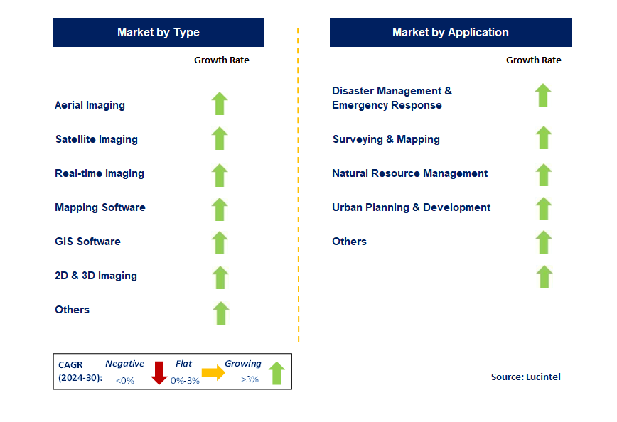
• Aerial Imaging
• Satellite Imaging
• Real-time Imaging
• Mapping Software
• GIS Software
• 2D & 3D Imaging
• Others
• Vehicle Mounted Device
• Drones
• Mobile
• Backpack
• Others
• Disaster Management & Emergency Response
• Surveying & Mapping
• Natural Resource Management
• Urban Planning & Development
• Others
• Government & Defense
• Telecommunications
• Healthcare
• Education & Research
• Infrastructure & Construction
• Agriculture
• Others
• North America
• Europe
• Asia Pacific
• The Rest of the World
• United States: In the United States, the geospatial imaging market is advancing rapidly with the integration of AI and machine learning into imaging systems. These technologies enhance data analysis capabilities, allowing for more accurate and efficient interpretation of geospatial data. The U.S. is also seeing increased investment in satellite technology and high-resolution imaging, driven by both government and private sector initiatives. Innovations in real-time data processing and the expansion of geospatial data applications in smart cities and autonomous vehicles are key trends shaping the market.
• China: China geospatial imaging market is expanding due to significant investments in satellite technology and infrastructure development. The country is focusing on enhancing its satellite constellation for improved Earth observation and data accuracy. Recent advancements include the development of high-resolution imaging satellites and increased use of geospatial data in urban planning and environmental monitoring. China is also leveraging geospatial imaging for applications in disaster management and agricultural optimization, reflecting the government's strategic interest in utilizing spatial data for national development goals.
• Germany: Germany is making strides in the geospatial imaging market with a focus on integrating advanced imaging technologies into environmental and urban management. Recent developments include the adoption of high-resolution satellite imagery and drones for detailed mapping and monitoring. Germany's emphasis on sustainability is driving the use of geospatial data in environmental protection and resource management. Additionally, the country is enhancing its geospatial imaging capabilities through collaboration with European Space Agency (ESA) projects and investments in new imaging technologies that support research and industry needs.
• India: India is experiencing growth in its geospatial imaging market, driven by increased government initiatives and technological advancements. The Indian government is investing in satellite technology and spatial data infrastructure to support urban planning, agricultural development, and disaster management. Recent developments include the launch of new satellites and the expansion of geospatial data applications in various sectors. India is also focusing on improving data accuracy and accessibility through collaborations with international space agencies and advancements in remote sensing technologies.
• Japan: Japan geospatial imaging market is evolving with a strong emphasis on precision and disaster management. Recent advancements include the deployment of high-resolution satellite systems and sophisticated imaging technologies for detailed mapping and environmental monitoring. Japan is also utilizing geospatial data to enhance disaster preparedness and response, particularly in earthquake and tsunami-prone areas. Innovations in imaging technologies and the integration of AI for data analysis are key trends shaping Japan's approach to geospatial imaging, aligning with its focus on safety and technological excellence.
• ESRI
• Fugro
• Hexagon
• Surdex Corporation
• Trimble
• Woolpert
• Pasco Corporation
• NV5 Global
• Asia Air Survey
• Cyient Limited Q6. Which geospatial imaging market segment will be the largest in future? Answer: Lucintel forecasts that real-time imaging will remain the largest segment over the forecast period. Q7. In geospatial imaging market, which region is expected to be the largest in next 5 years? Answer: APAC will remain the largest region over the forecast period. Q.8 Do we receive customization in this report? Answer: Yes, Lucintel provides 10% customization without any additional cost.


Choose a license that fits your team. Instant PDF delivery.
Prices exclude taxes. Instant delivery. Custom licensing available on request.
Market Report · July 31, 2026
Market Report · July 31, 2026
Market Report · July 31, 2026
Trusted partner for strategic intelligence and business growth


Receive a complimentary market analysis tailored to your industry. Our analysts will identify key growth opportunities and competitive dynamics specific to your business.

Market size, growth rate, and key trend analysis for your specific sector.

Top competitor positioning and market share analysis.

Strategic recommendations backed by data-driven insights.
Get curated market intelligence and competitive moves straight to your inbox.
By subscribing, you agree to receive our monthly insights. Unsubscribe anytime.
Receive a complimentary market analysis tailored to your industry. Our analysts will identify key growth opportunities and competitive dynamics specific to your business.
Market size, growth rate, and key trend analysis for your specific sector.
Top competitor positioning and market share analysis.
Strategic recommendations backed by data-driven insights.
Get curated market intelligence, emerging trends, and competitive moves straight to your inbox each month.
By subscribing, you agree to receive our monthly insights. Unsubscribe anytime.
We'll send your sample report shortly.