
Market Report · July 31, 2026

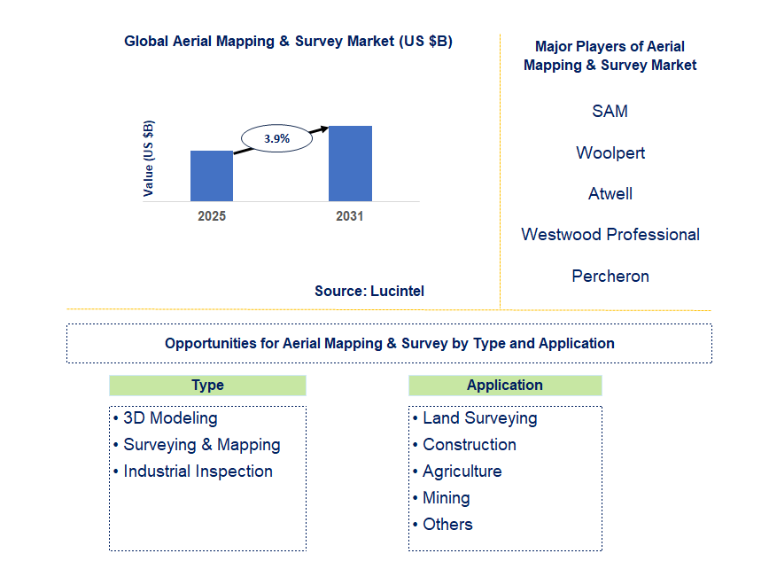
Key data points: The growth forecast = 3.9% annually for the next 7 years. Scroll below to get more insights. This market report covers Trends, opportunities and forecasts in aerial mapping & survey market to 2031 by type (3D modeling, surveying & mapping, and industrial inspection), application (land surveying, construction, agriculture, mining, and others), and region (North America, Europe, Asia Pacific, and the Rest of the World)
We'll send your sample report shortly.
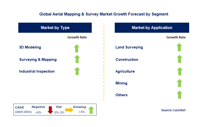
• Lucintel forecasts that, within the type category, 3D modeling is expected to witness the highest growth over the forecast period.
• Within the application category, construction is expected to witness the highest growth.
• In terms of region, APAC is expected to witness the highest growth over the forecast period.
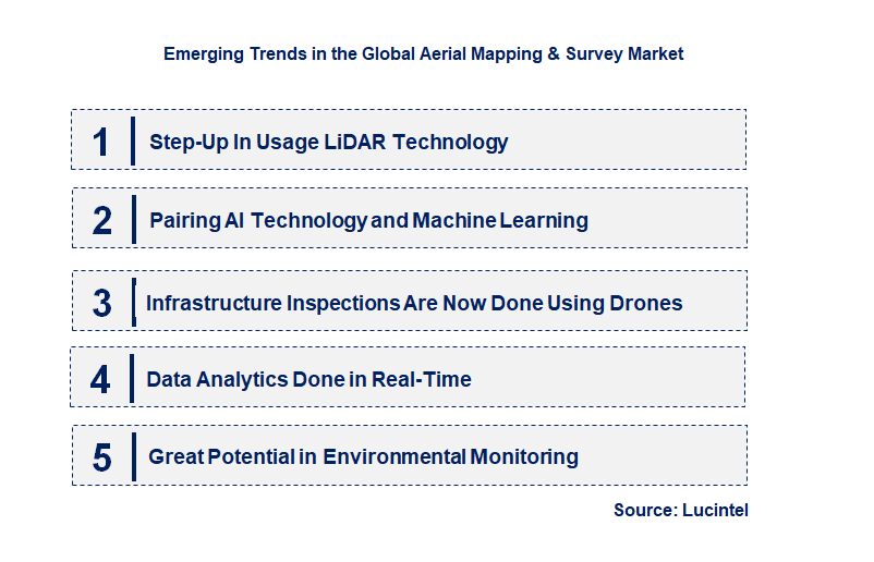
• Step-Up In Usage LiDAR Technology: Using LiDAR (Light Detection and Ranging) technology has greatly added the value of assessments and aeries mapping, as well as, their accuracy and dependability. A drone with LiDAR may construct vegetation and structures topographical maps from better drones automatically indexed CD views compact multiprocessor programs for range finders accuracy algorithms during autonomous mission flight in dense environments. This innovation is very important in the construction and design sector, forestry, and mining because elevation data is important to plan activities and perform precise analytical studies. The possibilities to operate with devices and navigate aircraft unmanned systems equipped with LiDAR will further improve the transformation processes in survey mapping and increase automated aerial survey procedures.
• Pairing AI Technology and Machine Learning: The application of AI and Machine Learning as features in aerial mapping systems has AI-enabled analyzing drone data to improve processes. AI algorithms can now analyze datasets, leading to better information and quicker results with less human involvement. This is helpful in agriculture where constant monitoring and prediction of plant yields make data analysis more beneficial. AI will automate several functions such as anomaly detection and feature recognition which will improve operational efficacy and create new possibilities in aerial surveying.
• Infrastructure Inspections Are Now Done Using Drones: The expansion of drones has enabled access to difficult areas for infrastructure inspections like bridges, powerlines, and towers. Drones can take photos and videos from multiple perspectives which ensures better accuracy and understanding compared to manual surveying which is expensive and takes so much time. Thermal cameras on drones enable the detection of cracks and heat loss in buildings. This shift is valuable in many industries but especially in utilities and transportation where changing infrastructure accurately and on time is critical.
• Data Analytics Done in Real-Time: The need for real-time aerial mapping analytics is on the rise due to the ready availability and reliance on accurate geographic information and data by businesses and governments. In-depth analyses and data collection expedite decision-making processes, especially in agriculture, construction, and emergency response. For instance, aerial farm surveys can provide real-time data for irrigation and pesticide use decision-making. This is making companies develop advanced systems that can offer actionable insights on the fly propelling the productivity value of aerial mapping.
• Great Potential in Environmental Monitoring: Aerial mapping, and aerial surveys play a crucial role in monitoring the environment because data collection through drones for remote locations is simple and quick. Applications higher include; deforestation detection, pollution analysis of water bodies, and natural disaster impact assessment. The ability to capture large-scale environmental data efficiently, routinely, and swiftly has resulted in the adoption of aerial surveys by environmental agencies and firms, expecting to increase alongside with the growing global environmental movement. There is great need to address climate change and implement sustainability measures. New trends in the aerial mapping & survey market focus primarily on vertical technologies enhancing the precision, productivity, and applicability of aerial surveys. Advancements in LiDAR technology and AI, in addition to real-time data analysis, are also fostering innovation. New opportunities for growth are emerging with the use of drones for infrastructure inspections and environmental monitoring. These developments are making aerial mapping services accessible, economical, and beneficial, not only to the agricultural and resource management sectors but also to disaster management, thereby dynamically transforming an evolving market.
• Progress in UAV Technologies: Continuous improvement in UAV tech has greatly aided areas like mapping. Newer models of UAVs come with longer range flights, advanced GPS systems, and higher payloads leading to more accurate and detailed data collection over large areas. This, in turn, has made drones an essential mechanism for industries such as construction and agriculture which require high precision surveys on a frequent basis. There is further expectation of the market growth for aerial mapping and surveys drones, as more sophisticated technologies emerge, which will be advantageous for both businesses and governments.
• Enhanced Software for Data Processing: Improved data processing software has optimized output and precision in mapping services. Currently available software allows for real-time analytics, automation, and storage of VAST amounts of data collected from UAVs. This advancement leads to better decision making and increased insights, especially for sectors such as urban planning and agricultural. In addition to that, enhanced software solutions are helping in the creation of sophisticated models to more detailed visualizations, which in turn is prompting commercial and governmental users to integrated aerial surveys.
• The Intersection of Thermal Imaging and Multispectral Imaging: The incorporation of thermal and multispectral imaging into aerial mapping systems has been a game-changer for agriculture, construction, and environmental monitoring. Drones that are equipped with these imaging technologies can enhance understanding of temperature differences, crop health, and general environmental conditions. This is useful in precision agriculture where farmers are able to monitor the health of plants and optimize irrigation systems accordingly. The incorporation of these imaging systems is helping broaden the scope of aerial mapping beyond surveying, making it useful in many different fields.
• Initiatives and Policy Changes: Around the globe, governments are providing more structured and more supportive policies for drone use, particularly in aerial mapping and surveying. Such policies guarantee the safe and efficient utilization of UAVs, thereby increasing confidence in the technology among industries and consumers. For example, in the United States and China, as well as Germany, the existing policies are speeding up the use of solutions based on aerial surveying. With ongoing policy changes, there will be increased access to services offered using aerial mapping tools, leading to greater use across different industries.
• Broader scope of business use: A lot more has been done commercially with aerial mapping technology in the recent past. Construction, infrastructure, and mining industries are increasingly utilizing UAV aerial surveys due to improved efficiency and cost saving measures. Drones are routinely used for construction site monitoring, environmental assessments, power line inspections, and even more. Increased commercial application has created a market need for more dedicated aerial mapping services. This is likely to persist as businesses understand how Aerial Surveys enhance accuracy and workflows across the board. The Aerial Mapping and Survey market is undergoing changes with new UAV features, new data processing tools, and the addition of thermal and multispectral cameras. These advancements make aerial surveillance more precise, effective, and usable in various sectors like agriculture and infrastructure. The market will continue expanding due to these innovations that make it easier for Entrepreneurs and service providers to access new business opportunities, alongside the evolving regulations.
• Agriculture and Precision Farming: Aerial mapping and surveys are increasingly used in agriculture, especially for precision farming. Drones equipped with multispectral and thermal sensors can monitor crop health, track growth, and assess soil conditions with high accuracy. This provides farmers with real-time data that helps optimize irrigation, fertilization, and pest control, ultimately leading to higher yields and cost savings. As the demand for sustainable and efficient farming practices grows, the agricultural application of aerial mapping will continue to expand, creating significant opportunities for service providers in the market.
• Construction and Infrastructure Monitoring: In the construction and infrastructure sectors, aerial mapping solutions are being widely adopted to monitor progress, assess risks, and ensure safety. Drones are used for surveying large construction sites, generating accurate 3D models, and tracking project timelines. This real-time data collection and analysis help streamline operations, reduce costs, and improve decision-making. As infrastructure development continues to rise globally, there is a growing demand for aerial mapping services to support large-scale projects. This application is a key area of growth for the industry.
• Environmental Monitoring: Aerial mapping is increasingly used for environmental monitoring, providing valuable data on ecosystems, land use, and climate change. Drones are particularly useful for tracking deforestation, monitoring water bodies for pollution, and assessing the effects of natural disasters. As environmental concerns grow worldwide, governments and organizations are turning to aerial mapping solutions to support conservation efforts and sustainable land management practices. This presents a substantial growth opportunity for companies offering aerial surveying services tailored to environmental applications.
• Urban Planning and Smart Cities: Urban planning and the development of smart cities are another key area for growth in the aerial mapping & survey market. Drones provide high-resolution imagery and detailed maps of urban areas, enabling planners to analyze infrastructure, traffic patterns, and land use. With the rise of smart cities, there is a growing need for accurate, up-to-date geospatial data to plan and optimize urban development. This trend is fueling the demand for aerial mapping services that can support everything from zoning and transportation planning to utilities management.
• Disaster Management and Emergency Response: Aerial mapping plays a critical role in disaster management and emergency response, particularly in assessing damage, monitoring recovery efforts, and providing situational awareness in real-time. Drones can quickly capture high-resolution images of affected areas, helping first responders and government agencies make informed decisions. As natural disasters become more frequent and intense due to climate change, the need for rapid and accurate aerial surveys will continue to rise, presenting significant opportunities for growth in this application. The aerial mapping & survey market is experiencing significant growth across multiple applications, from agriculture and construction to environmental monitoring and disaster management. As industries adopt drone-based mapping solutions for efficiency, precision, and cost savings, these key applications offer substantial growth opportunities. Companies in the market must focus on these sectors to capitalize on the increasing demand for high-quality aerial surveys, ultimately shaping the future of the industry.
• SAM
• Woolpert
• Atwell
• Westwood Professional Services
• Percheron
• SAF Aerogroup
• Aescit Spatial Analysis
• ARC Aerial Imaging
• Fugro
• Applus+
• 3D Modeling
• Surveying & Mapping
• Industrial Inspection
• Land Surveying
• Construction
• Agriculture
• Mining
• Others
• North America
• Europe
• Asia Pacific
• The Rest of the World
• United States: The US remains the most dominant player in the aerial mapping & survey market, fueled by innovation in technology and greater commercial, governmental, and environmental use. The widespread use of drones, along with LiDAR (Light Detection and Ranging) technology has made mapping far more accurate and efficient than before. New policies set by the Federal Aviation Administration are also supporting the growth of UAVs-enhanced aerial mapping services. With the introduction of real-time data analytics, the demand for aerial surveys in infrastructure development, agriculture, and land surveying has risen tremendously, which greatly benefits the US economy.
• China: Due to the rapid development of infrastructure in the country, China has seen and is expected to further see growth in the Aerial Mapping and Survey market. There has been increased adoption of drones for surveying in construction, mining, and agricultural sectors as well. Particularly with China's government initiatives aimed at smart cities and precision agriculture, there is a strong promotional push for drones being used for mapping and surveying. In addition, technological advancements with regards to the drones themselves, such as better battery life, more data capturing methods, as well as improved data collection, have all made aerial drone mapping more efficient and cost-effective which helps expand the market further.
• Germany: Germany is one of the strongest contributors in the Aerial Mapping and Survey market in Europe. Germany has made notable investments in drone technology and the country’s construction, land management, forestry industries are benefiting from better mapping services. Use of drones in surveying land and planning for construction projects has improved accuracy while also lowering costs. Germanys commitment towards sustainability and the use of drones for surveying in environmental monitoring such as forest management and wildlife conservation has increased the demand for aerial mapping, thus proving to be a significant contributor towards drone mapping services.
• India: In India, the aerial mapping & survey market is growing at a tremendous rate due to the focus on providing mapping solutions in Indian agriculture, urban planning, and infrastructure development industries. The Indian government seems to be well aware of the potential offered by drone technology and is putting in considerable efforts to build the policies. Topographic surveys, crop monitoring, and urban planning are some of the areas where drones are being increasingly utilized. Furthermore, the advancements in drone technology and their declining costs have increased the use of aerial mapping services for rural and remote areas which is aiding the growth of the market in India.
• Japan: Japan is also a major participant in aerial mapping & survey market alongside Japan’s disaster management, infrastructure, and agriculture division. Drones survey the land in order to collect information needed for agriculture and infrastructure due to Japan’s focus on accuracy and efficiency. Japan’s focus on precision and efficiency has also driven the use of UAVs for mapping purposes. Reconnaissance surveying because of the countries frequent occurrence of natural disasters like earthquakes and typhoons has increased the demand in order to survey the devastated areas and aid recovery efforts. Japan’s focus on strategic governance due to the constant degeneration of the country’s infrastructure and rapid pace of smart city developments has further increased the need for high-precision aerial mapping services Japan is being strategically positioned as a strong market increase aerial surveying technologies.

• SAM
• Woolpert
• Atwell
• Westwood Professional Services
• Percheron
• SAF Aerogroup
• Aescit Spatial Analysis
• ARC Aerial Imaging
• Fugro
• Applus+ Q5. Which aerial mapping & survey market segment will be the largest in future? Answer: Lucintel forecasts that, within the type category, 3D modeling is expected to witness the highest growth over the forecast period. Q6. In aerial mapping & survey market, which region is expected to be the largest in next 5 years? Answer: In terms of region, APAC is expected to witness the highest growth over the forecast period. Q7. Do we receive customization in this report? Answer: Yes, Lucintel provides 10% customization without any additional cost.
Choose a license that fits your team. Instant PDF delivery.
Prices exclude taxes. Instant delivery. Custom licensing available on request.
Market Report · July 31, 2026
Market Report · July 31, 2026
Market Report · July 31, 2026
Trusted partner for strategic intelligence and business growth


Receive a complimentary market analysis tailored to your industry. Our analysts will identify key growth opportunities and competitive dynamics specific to your business.

Market size, growth rate, and key trend analysis for your specific sector.

Top competitor positioning and market share analysis.

Strategic recommendations backed by data-driven insights.
Get curated market intelligence and competitive moves straight to your inbox.
By subscribing, you agree to receive our monthly insights. Unsubscribe anytime.
Receive a complimentary market analysis tailored to your industry. Our analysts will identify key growth opportunities and competitive dynamics specific to your business.
Market size, growth rate, and key trend analysis for your specific sector.
Top competitor positioning and market share analysis.
Strategic recommendations backed by data-driven insights.
Get curated market intelligence, emerging trends, and competitive moves straight to your inbox each month.
By subscribing, you agree to receive our monthly insights. Unsubscribe anytime.
We'll send your sample report shortly.